It’s starting at 8:30 a.m. Saturday, April 11. From the East Bay Regional Parks events page:
SUNOL – It’s time to celebrate the birds, bees, flowers and trees during the 7th annual Wildflower Festival. Join us as we celebrate the rebirth of spring during a series of hikes, crafts, music, slide shows, and nature exhibits. Hikes are geared for different ages and topics – there is something for everyone. So bring a picnic lunch, put on your hiking boots and join us for a day filled with flowers! No registration, drop in program. For information: (510) 544-3240
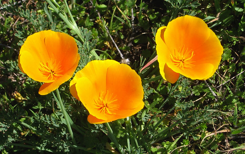
Some California poppies to get you in the mood:
The festival’s free but parking costs $5.
Alas, Saturday’s an earn-a-living day for me, so I’ll have to pass. Though, truth be told, I generally avoid guided-tour stuff (I’d much rather stumble around in ignorance than have somebody answer all my questions). Also, it’s apt to be crowded.
But: if you’ve never gone out on a naturalist-guided hike, you really should try it at least once. Say, for instance, you went to the Wildflower Fest thinking “I’m not going to hike, I’m going to learn,” you might have a better chance of enjoying yourself.
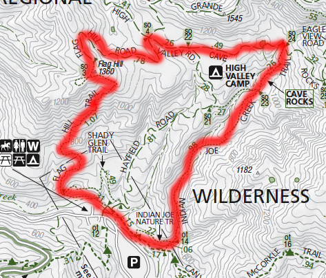
I’m trying to think if any places at Sunol have more wildflowers than others. Generally the brutal climb to Flag Hill has lots of poppies, which thrive on steep, sunny slopes. If you consult your Sunol map you’ll see the “Flag Hill Trail” and might logically assume it’s the best way up there. Well, only if you feel you owe yourself a workout (or want to wear out the kids). This map offers an alternate route known to all who adore Sunol:
The Flag Hill Trail over on the left climbs about a thousand feet in a mile. Serious leg-burner action. A friendlier alternative is to take the Indian Joe Creek Trail on the right, hang a left on the High Valley Road Trail, then hang another left at the Flag Hill Trail. It’s about twice as long, but you get to climb an excellent riparian corridor on the Indian Joe Creek Trail, you can rest up at Cave Rocks, and take a more gradual trip to the top of Flag Hill.
The view at Flag Hill is one of the best in the Bay Area.
Returning via the Flag Hill Trail is up to you. If you have bad knees that make you feel suicidal on downhills, you might want to go back the way you came. Here’s my favorite pic from a particularly treacherous patch:
I’m guessing it’ll seem a bit overpopulated Saturday, but you never know till you head up there.
Here’s my Google map for getting to Sunol Wilderness.
View Sunol Wilderness trail heads in a larger map


My favorite variant of Flag Hill is to take Hayfield Road up, past the fields of Owl’s Clover and onover to Flag Hill. Not real tough, but a nice little loop.
Alas, we’ll be at Carrizo Plain this weekend, missing the Flower Fest at Sunol. Crossing fingers the rain steers north…
The wildflowers were looking pretty good at Sunol on 4/4. You’re so right about Indian Joe Creek Trail being the only sane way to get to the higher parts of the park! Flag Hill is way steep, as is Cerro Este & McCorkle.
The flowers on Cerro Este are very nice right now, especially on the dead-end that continues up from the Cerro Este Overlook to the park boundary (hills 2038 & 2201 on the park map). I’ll post about that walk in a day or two – IMO the Indian Joe Creek/Flag Hill loop & the Indian Joe Creek/Cerro Este/McCorkle loop are two of the best hikes in the bay.