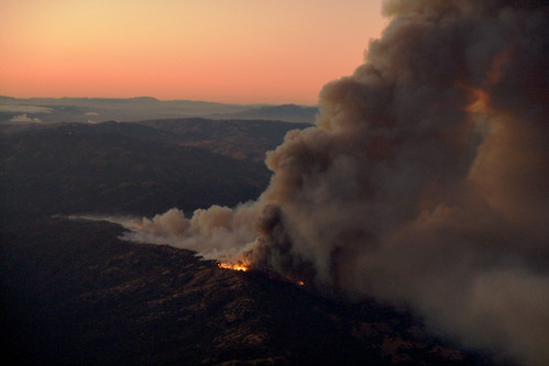
“Fire at Henry Coe State Park in California,” from the photo stream of d^b.
A Flickr user flying into San Jose last night snapped this pic of the big fire burning near Henry Coe State Park. Word this morning is that 3,000 acres have burned already and that the blaze is “zero percent” contained.
Here’s a Mercury News update on the fire. Here’s an older post with user comments, which are occasionally instructive (ignore the ones about Merc attacks on firefighter pensions, which are almost ridiculously lavish compared to the pensions afforded to others in high-risk jobs — cabdrivers spring to mind. Yes, guys, you are heroes. You do amazingly daring, scary work. But you’re cashing in on your hero status with these pensions and you know it. Public decency obliges some circumspection. OK, off-topic rant over.)


Henry Coe is flat out my favorite park in the Bay Area. Last week I went up to the Ponderosa Loop in the late afternoon to photograph the sun glistening on the tall golden grass there. I still have half a roll of film in my camera and thought about going back yesterday to finish it off but didn’t get it together to do that. A good thing as it turns out. And then last night I could see the red glow of the fires from my home in San Jose and I am just hoping they can contain it. And I’m with you Tom, those fire fighters sure are heroes to me too!
They’re probably more than a little nervous up in San Antonio Valley, too. There is nowhere to run in that small community, just the long drive to Patterson or Livermore. I’m guessing a bit about the direction of this fire, but let’s hope the air support can cslow this thing down today.
I figure this to be an awful summer / fall for fires. It’s just too dry. And the fall offshore – flow winds haven’t even started yet…
I saw the column of smoke from I-505 north of Davis on the way back from the Lassen area last night. At first, I thought I must be seeing a fire on Mount Diablo.
According to the reports everyone points to, the fire is mostly north and somewhat east of Mount Sizer, which puts it (mostly) outside of the most visited parts of the park. If the fire is advancing more east than north, I suppose it could be hitting Bear Mountain and the northern part of the Orestimba Wilderness.
I can’t wait to see a detailed map of the actual burned area. This is where relatively real-time satellite images would be useful.
From the reports, the fire is moving to the southeast, so San Antonio valley and Lick observatory should be ok. That is the prevailing wind direction this time of year (as hot air in the central valley rises and sucks in cooler air from the coast). I haven’t looked at interior temps today, but the cooler temps around the bay should help.
Fighting wildfires is hot, nasty, dirty work. My sister did it for a summer until poison oak put her on the DL (disabled list for those of you who don’t follow my baseball blog).
Saw the smoke driving to the airport yesterday and was debating whether it was smoke or a cloud.
I was wrong
> I suppose it could be hitting Bear Mountain
> and the northern part of the Orestimba Wilderness.
That traverse from the road over to Bear would certainly be easier post-fire.